

(For more information about the project's background, see our "About" page.)
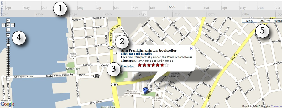
1: Timeline
Drag, double-click, or scroll with a mouse wheel to move backward or forward through the timeline. The top band is delineated by year, and this band determines what markers appear in the map. (In this example, anyone active during the period from April 1751 to July 1752 will be represented by a marker on the map). For moving through time more quickly, the bottom band is delineated by decade.
2: Information Bubble
The information bubble offers the most basic information about when and where a member of the book trade was active. Follow the "Click for Full Details" link to access the full record in the database.
3: Precision Rating
The evidence for a location on the atlas is sometimes very precise (e.g. John Carter at 21 Meeting Street), but in other cases we don't know more than the town in which they operated. The rating system is an attempt to give a (rough) sense of how precisely a marker is located, using the following system:
| Rating | Area of Precision | |
|---|---|---|
| = | State | |
| = | Town | |
| = | "" | |
| = | District / Neighborhood | |
| = | "" | |
| = | Block | |
| = | "" | |
| = | Individual House or Building |
(Note that this is not a measure of implied accuracy.)
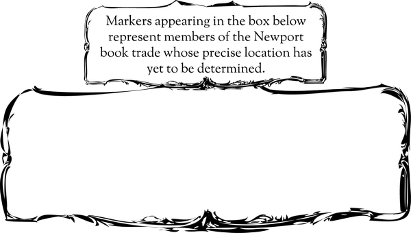
The towns of Providence and Newport required an additional step: Because of the large number of members of the book trade identified as being from one or the other town but with no location more precise, either leaving them off the map or placing them in a central location would have skewed the representation of the book trade in those towns at that time. As a result, an arbitrary location away from other markers was chosen for each town and markers identified simply as "Providence" or "Newport" were placed within a box like the one below:
4 & 5: Map Controls
Controls on the left of the screen control zoom and pan. Use the controls on the right to switch map views between street map, satellite view, and topographic terrain view.
Linking to Map Views
To copy a link to the current map view, click the "Link to this View" link and then copy the link from the address bar of the browser.
Viewing Options
- Fullscreen: Timeline + Map.
- Fullscreen with Historic Map Overlays: Includes historic overlay images for Newport—Charles Blaskowitz's 1777 A Plan of the Town of Newport (courtesy of the Library of Congress)—and Providence—Daniel Anthony's 1803 Map of the Town of Providence (RIHS collections, image number RHiX34580) - N.B. Overlay images may take a few moments to load.
- Static Map: View the map showing markers for the entire period.
- Static Map with Overlays: View the map showing markers for the entire period as well as the historic overlay maps.